At the Info-Activism Camp 2013 Hagit Keysar brought along a kite. We soon learnt it could do more than just fly: this kite took photographs and was an important map-making tool. Hagit tells us here why she flies kites to make maps in Jerusalem.
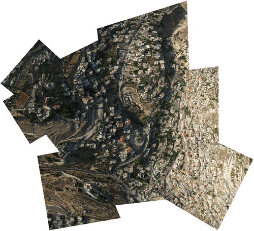
DIY aerial photography made with Palestinian children in Silwan, East Jerusalem
It’s been two years since I discovered a passion for collaborative map-making techniques and in particular Do-It-Yourself (DIY) aerial photography. It’s hard to explain how it happened as I am not an expert in any of the related fields. I’m not a cartographer, not an artist and not a geographer. I’m neither a technologist nor an environmentalist and nor am I a scientist. Yet I am interested in all of these areas of expertise and my experience with map-making has made it possible for me to explore them.
I’ve learnt new skills by doing aerial photography with inhabitants in Jerusalem − Palestinians and Israelis − documenting, investigating and representing different issues and stories that concern them in the city. There is a lot to do in the Palestinian-Israeli space in terms of negotiating its representations in maps and aerials. One just needs to compare the maps of Gaza or Ramallah between google maps and openstreetmap to understand the politics of digital cartographic representations. Yet, for me, the central impetus for producing independent and DIY aerial photography of the contested city is not fighting the dominant narrative represented on existing and conflicting maps; rather, my interest is in tools that would enable us to develop new ways of seeing in the city. By this I mean liberating the way we act, move, navigate and identify relations between places and people, from the stronghold of authoritative ways of seeing. Let me try to explain.
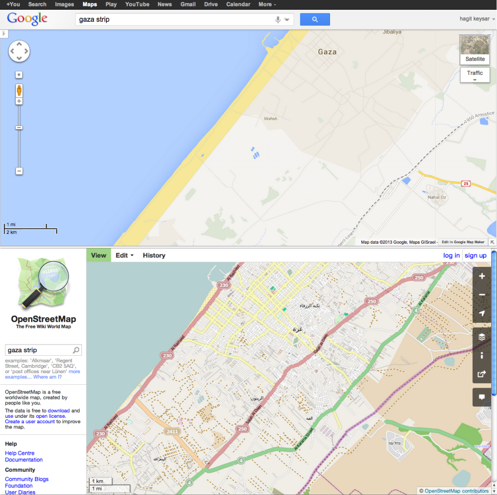 Gaza strip in Google maps and OpenStreetMap
To begin with, lets agree that photographs are manipulations. They do not need to be edited and altered for them to be understood as manipulations; they are such in the simple fact of their making, since they are a technical translation of a reality; an interpretation that is then interpreted again and again by others. Without undermining photographs as an important source of information, I think we are increasingly conscious of the ambiguity and interpretive ground they convey. Now more than ever, we tend to interpret and judge the credibility of a photograph not just by observing the image or its caption, but rather by the image’s meta-data that can reveal the hidden mechanisms related to the politics and the context in which it was produced and used.
 Photograph taken in Israel in 1948 from the IDF and Defence Archive
See, for example, this photograph above from the IDF and Defence Archive, taken in 1948, the year in which the state of Israel was established and the violent expropriation and expulsion of Palestinian property and lands took place. The archive’s caption says “Arab citizens harvesting crops in the fields; Haganah members guarding them”. In 2009 curator and visual culture theorist Ariella Azoulay exhibited this photograph pointing at excess of details which contradict the caption it was given. Rather than harvesting, the photographed event seems to show the burial of something inside a pit, which causes the soldiers to protect their mouths and noses from some powerful stench. Indeed, interpreting an image is more about what you don’t know or see, rather than what you do, an authoritative caption can serve as a way to block our vision, distract us from looking, investigating and asking questions.
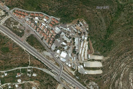
Beit Horon 2011
Beit Horon (with Israeli Censorship) 2010
This critical understanding of photography as a social as much as a technical practice is widespread and an everyday practice for so many of us. We are all photographers of sorts, knowingly shaping our identities, relations and memories by using photos to tell our stories and make claims about reality and our experiences. The massive global distribution, circulation and decentralisation of photography is establishing what Azoulay calls a “civil imagination” that connects and activates people around the globe, across borders and beyond political restraints. It keeps us alert with the understanding that a photograph never represents a static, objective reality of a univocal evidence, but is ground for politics, interpretation, contestation and conflict. What I find interesting is that this critical consciousness tends to dissolve at a certain elevation. Photographs taken from the sky or space still act as an authoritative source of information in our world; so much so that we hardly notice their effect on us. As Laura Kurgan; puts it, this visual regime disorients under the banner of orientation. It’s true that since the commercial release of aerial and satellite photographs more people participate in annotating the maps of the world by adding text, images and videos using platforms such as Google maps. But do we ever ask ourselves what, how and why do we see what we see when we “fly to” all kinds of places in the world using Google Earth? Do we notice that some places are represented in high resolution while others seem blurry? Do we ask about the islands or favelas that are missing or less annotated? Can we detect traces of censorship on the aerial photograph? Unlike photographs made on the ground, we denote neutrality, scientific value and credibility to these aerial representations of our world, even though we know so little about how they were produced and how they are being used.
Let me give an example of how this authority can be challenged. In April 2010 an explosion caused a massive oil spill that poured more than 200 million gallons of oil into the Gulf of Mexico over a period of four months. We could not learn of the spill’s damages due to US government and British Petroleum’s restrictions on flights above the area and limitations on media access. It was only after a group of activists got together with local residents to create aerial photography using kite mapping techniques, that a detailed visual documentation of the spill’s expansion and damages was publicly revealed. These images opened up not only the way people could understand the extent of the oil spill damages but also an opportunity to do something about it.
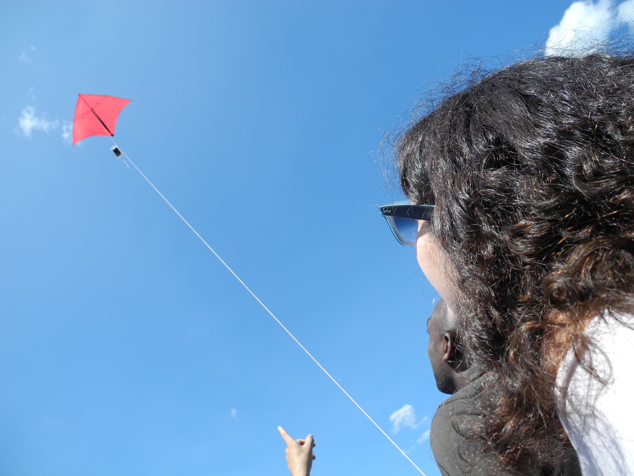
The group of activists and technologists who captured these images, The Public Lab, aim to promote civic science and democratise technology in ways that enable marginalised and excluded communities to document and investigate environmental issues. It’s a growing, global open-source community which operates both online and offline. My work in Jerusalem has been largely inspired and supported by the Public Lab’s community of practitioners. In the framework of the education-lab in Mamuta Art and Media Centre, Public Lab’s co-founder Jeffrey Warren worked with Shai Efrati and myself to design and implement our first DIY aerial photography projects with residents in Silwan, East Jerusalem and in Ein Karem in West Jerusalem. We used the Public Lab’s balloon and kite aerial photography toolkits to do this which includes both hardware for building camera rig and software for sorting and stitching the images into a geo-rectified, high resolution aerial map.
The ease of access and use of both hardware and software are opening an incredible opportunity to develop the critical consciousness that is missing in relation to aerial and satellite imagery. One just needs to go through the process of taking the photographs from the air, warping, distorting and stitching them together, to realise that what seems to be a simple, objective, unambiguous image of the earth, is a hand-made manipulation that calls for interpretation. But also, that this kind of high altitude photography offers new ways to tell stories and ask questions while placing people, things and places in relation to one another within urban or other environments.
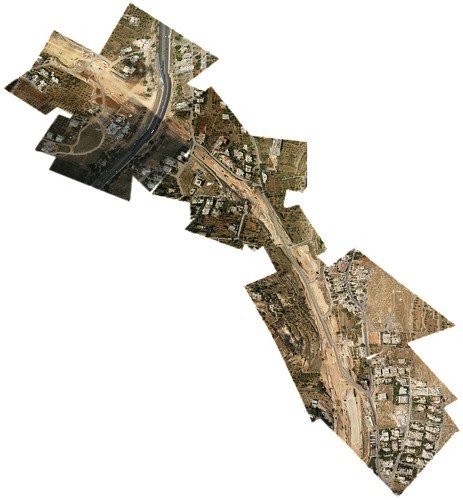
Mapping the construction of a contested highway severely damaging community and quality of life for Palestinian residents of Beit Safara, South-East Jerusalem.
Doing DIY aerial photography in the context of the Israel-Palestine political conflict introduces extra complexities. A salient question that arises is the ambiguity of its possible legal consequences. Legal regulations may be similar in Palestinian East Jerusalem and in the West Jerusalem’s Jewish areas, but practically, taking aerial photographs in each area is a very different experience. Both workshops we did went on peacefully but we had to consider the fact that creating DIY aerial photography above the highly controlled and militarised area of Silwan is an activity liable to raise authorities’ suspicion and intervention, including searching and arresting participants; while in the Western city’s Jewish environment, this reaction was far less likely to happen. Despite this tension, whether in East or West Jerusalem, the ease and playfulness of sending a kite with a camera into the sky and then using the images to stitch together a geo-rectified map has allowed people to tell a completely different story about their urban environment. For all of us who cross checkpoints and live a daily routine of segregation, spatial restrictions and limitations of freedoms, it’s a reminder that the geography and its imagery should be made open to everyone so it can be equitably understood, visualised and interpreted by its inhabitants, whoever they are − Jews, Palestinians, citizens and non-citizens, experts and non-experts.
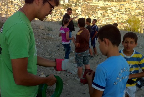
Jeffrey Warren and children from Silwan, flying a camera tethered to a kite.
Additional Resources:
More about the Jerusalem Mapping
Kite Mapping how-to on Public Lab
Mamuta Art and Media Center, Jerusalem
Flickr: fiestinx
Hagit collaborates with the PublicLab.org, she is also a Ph.D candidate in the BGU Politics and Government department, and an activist who currently lives in Jerusalem, Israel, Palestine.
4 thoughts on “Seeking new ways of seeing – collaborative mapmaking in Jerusalem”
Comments are closed.
Hi Hagit, I’ve been perusing the link you provided from OpenLab and it does seem to me I can buy a basic kite kit from them for about US$100. The balloon mapping kit looks to be the same price. From what I can work out balloons will give a better, more stable result but won’t be useful if there is too much wind or the weather is a bit choppier but also they can be a hassle since you have to source helium (how does one do that??)? How easy do you think it’d be for a novice with no experience to use the kite kit? is there a video or simple 10 steps type link you can recommend and what kind of first time results might I expect? I guess this so much depends on the camera you use? What sort of camera do you use? I found your story inspiring and really want to try this out. Thanks! Will def keep reading too. Tanya
http://publiclab.org/wiki/guides is a good place to start. If you have further questions I encourage you to subscribe to one of the appropriate mailing lists.
thanks Dan. I am about to order a kit so let’s see how it goes!
Hi Tanya, as Dan wrote you should definitely subscribe to the mailing list, people are usually very responsive and extremely helpful. If you are not in the US you might want to check the possibility of creating your own kit. It can be cheaper and easier. See the details for kite mapping here: http://publiclab.org/wiki/kite-mapping you’ll find many answers there, but also sign in to the public lab, tell the grassroots mappers you are about to do a flight – maybe someone who has experience is close by in your area and can help you with your first flight, might also be able to share equipment. Create a research note in the Public Lab website, this can be a short description of what you set out to do and how it went, your next steps and such… good luck!